Our Products and Add-ons
M360 Standard Package
M360 Standard Package

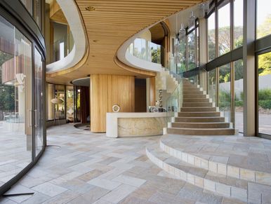
M360 Standard Package is a combination of professionally drafted floor plans and 360-degree visuals to make a virtual tour experience that includes detailed measurements of a property. It is well suited for documenting and/or marketing a property but can also be used for construction walkthroughs where floor plan accuracy and area totals are important.
Key features include:
- Virtual tour experience with professionally drafted floor plans for navigation and 360-degree visuals
- PDF floor plans (DO NOT include details such as fixtures, appliances and partitions)
- Area totals compatible with RECA RMS and ANSI measurement standards
- Room Dimensions
- Real-Time Asset Tagging
- Content Delivery platform features such as Photo Gallery, Analytics Report, Video Integration, Neighborhood Map, Branding, access to the Embedding Tool and Feature Sheet Creator.
ONLY Available Add-on(s):
- Aerial Drone 360 panoramas
- CAD Floor Plan (DWG)
- Extra Tags
M360 Premium Package
M360 Standard Package

Our most popular package! M360 Premium is a combination of professionally drafted floor plans and 360-degree visuals to make a virtual tour experience that includes detailed measurements of a property. 2D objects are an additional feature of this package where existing details, such as freestanding objects, fixtures, and appliances, are added to the floor plans to help a viewer better visualize a space. It is well suited for marketing a property to showcase it on any platform but can also be used for construction walkthroughs and insurance claims where floor plan accuracy and area totals are important. This one is perfect for Google Street view!
Key features include:
- Virtual tour experience with professionally drafted floor plans for navigation and 360-degree visuals
- Detailed PDF floor plans (includes fixtures, appliances, and partitions).
- Viewable in VR
- Area totals compatible with RECA RMS and ANSI measurement standards
- Room Dimensions
- Real-Time Asset Tagging
- Content Delivery platform features such as Photo Gallery, Analytics Report, Video Integration, Neighborhood Map, Branding, access to the Embedding Tool and Feature Sheet Creator
- ESX files will represent cabinets and complex ceilings
- DWG file will include fixtures, appliances, and cabinets.
Available Add-on(s):
- CAD Floor Plan
- Aerial Drone 360 panoramas
- Reflected Ceiling Plan
- Exterior Elevations
- Roof Plan
- Plotted Plans
- 3D Model (RVT or DWG)
- Extra tags
RADIX Construction Timeline Package

A virtual tour like experience that includes a point could for navigation as well as 360-degree visuals. It is typically available within hours of our visit and will show the data exactly as it was captured. Its flexibility and speed make it well-suited for documenting spaces for construction progress monitoring or for capturing data to be used as an underlay for 3rd party drawing software.
Key features include:
- Virtual walkthrough with point cloud for navigation and 360-degree visuals
- DXF file download with point cloud data
- Real-Time Asset Tagging
- Content Delivery platform features such as Photo Gallery, Video Integration, Neighborhood Map, Branding, access to the Embedding Tool.
Available Add-on(s):
- Aerial drone images
- Aerial Drone 360 panoramas
- Extra tags
Architectural & Drone Photography
Architectural & Drone Photography
Showcase your spaces with high-quality architectural photography that captures design, scale, and craftsmanship. Measure360 provides professional interior and exterior photography tailored for architects, builders, designers, and property owners. Our images highlight materials, lines, and spatial flow—perfect for marketing, portfolios, documentation, and project records. Whether it’s a completed build or an active project, our photography delivers clear, polished visuals that elevate your work and tell the full story of the space. We offer Aerial drone photography as well.
CAD Floorplan Add-on
Architectural & Drone Photography
CAD Floorplan Add-on

The CAD Floor Plan includes a drafted floor plan (DWG) and lidar point cloud data for all floors (DXF) to provide more complete documentation of your property and acts as a head start for Architects, Designers, and Contractors. For a more detailed description of what is included in the DWG file.
This Add-on includes:
- Drafted floor plan (DWG)
- LOD 200: Interior wall thicknesses are set to North American standards, and exterior spaces are included (patios, decks, porches, etc.)
- AIA standard layers with annotations including labels, area totals, objects dimensions, etc. (Advanced Drawing Package and Premium only)
- Lidar point cloud data of all drafted floors (DXF)
Availability:
- The CAD Floor Plan Add-on is available with both an M360 Standard or Premium Package
- When ordered alongside a Standard Package, it's provided with reduced detail.
3D Model Add-on
Architectural & Drone Photography
CAD Floorplan Add-on

This 3D Model file is offered in either DWG or RVT format and is intended as a head start for Architects, Designers, and Contractors. For a more detailed description of what is included in the 3D model file.
This Add-on includes:
- 3D model (DWG or RVT)
- Includes walls, doors, windows and basic structural elements
Availability:
- This add-on is available with the Premium package and is delivered in DWG or RVT format for compatibility with most CAD software
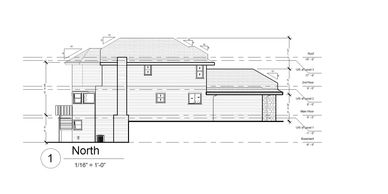
EE (Exterior Elevation drawings) Add-on
EE (Exterior Elevation drawings) Add-on
EE (Exterior Elevation drawings) Add-on

Exterior Elevations are architectural drawings that show the exterior façade of a building. These drawings provide a flat representation of each side of the structure, offering valuable insight into the building’s external appearance and design. For a more detailed description of what's included in the Exterior Elevations file.
This Add-on includes:
- Drafted exterior elevation drawings (DWG)
- Includes front, rear, and side views of building façade(s)
Availability:
- This add-on is available with the Premium package and is delivered in DWG format for compatibility with most CAD software
RCP (Reflected Ceiling Plan) Add-on
EE (Exterior Elevation drawings) Add-on
EE (Exterior Elevation drawings) Add-on

Reflected Ceiling Plans (RCPs) are architectural drawings that show a space's ceiling layout. Unlike typical floor plans, which depict walls, doors, and windows, RCPs focus solely on the ceiling elements and are mirrored to match the floor plan. For a more detailed description of what's included in the Reflected Ceiling Plan file.
This Add-on includes:
- Drafted Reflected Ceiling Plan (DWG)
- Includes elements such as bulkheads, lighting locations, and ceiling height indicators
Availability:
- This add-on is available with the Premium package and is delivered in DWG format for compatibility with most CAD software
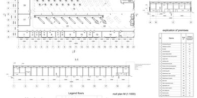
RP (Roof Plan) Add-on
EE (Exterior Elevation drawings) Add-on

Roof Plans (Pitched or flat) are architectural drawings that depict the layout and design of a building’s roof, including features such as slopes, edges, and roof details of the primary structure. For a more detailed description of what is included in the Roof Plan file.
This Add-on includes:
- Drafted roof plan (DWG)
- Includes slopes and roof edges of the primary structure
Availability:
- This add-on is available with the Premium package and is delivered in DWG format for compatibility with most CAD software
PDF Plotted Plans Add-on
BOMA Standard Measurement Add-on
This add- on provides plotted PDF plans that are easy to share and easy to submit to any city for Permits.
- Plotted Drawing Package
BOMA Standard Measurement Add-on
BOMA Standard Measurement Add-on
BOMA Standard Measurement Add-on
The Building Owners and Managers Association (BOMA) Standards are the industry gold standard for measuring commercial properties. They ensure that all property spaces—office, retail, industrial, and mixed-use—are measured consistently, providing clear, accurate data for leasing, buying, or managing properties.
Asset Tagging Add-on
BOMA Standard Measurement Add-on
BOMA Standard Measurement Add-on

All of our packages come with the ability to tag up to 20 assets such as Hot Water Tanks, HVAC units, gas meters, water lines. We can add extra tags in case 20 are not enough for your project.